New fire danger signs set to improve community safety
Published Thursday, 20th April 2023
Bushfire preparedness is getting a boost with nine upgraded Fire Danger Rating signs being installed across the City of Wanneroo.
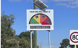
The upgraded electronic signs, recently received from the Department of Fire and Emergency Services (DFES), will align the City with national standards that improve public safety and reduce the impacts of bushfires by improving the accuracy of fire danger predictions and the way fire danger is communicated.
The signs feature four simplified ratings and wirelessly receive bushfire rating data directly from DFES.
Bushfire danger is rated on several factors including air temperature, relative humidity, wind speed and existing vegetation that could fuel a fire.
Mayor Linda Aitken said the upgraded signs would provide a more accurate fire danger rating to help the community understand when to action bushfire survival plans.
“The signs will increase the City’s bush fire preparedness and help protect our community, ensuring emergency information is reliable, consistent and accessible,” she said.
Six signs were installed last week, with a further three to come later this year.
While the roll-out takes place, it is recommended the community use the Emergency WA website to check fire danger ratings.
City of Wanneroo Fire Danger Rating sign locations
- Gnangara Road, Landsdale, east of Sydney Road
- Neaves Road, Mariginiup, west of Meadowlands Drive
- Wanneroo Road, Neerabup, north of Joondalup Drive
- Wanneroo Road, Nowergup, north of Hester Avenue
- Wanneroo Road, Nowergup, north of Reinhold Road
- Wanneroo Road, Yanchep, south of Yanchep Beach Road
- Two Rocks Road, Yanchep, north of Yanchep Beach Road
- Breakwater Drive, Two Rocks, east of Oregano Drive
- Neaves Road, Pinjar, corner Old Yanchep Road
More articles in the news archive.