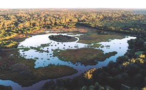
Wetlands
A large proportion of the City of Wanneroo is made up of a complex network of interconnected wetlands. Significant wetlands in the City include Lake Joondalup, Lake Neerabup, Badgerup Lake, Mariginiup Lake and Jandabup Lake. These wetlands contain vast assemblages of rare and protected flora, and they provide critical habitat to a range of native animals. They also provide valuable opportunities for recreation through a range of passive and active open spaces and interconnected paths and access tracks.
Wetlands Planning Policy
The City’s Local Planning Policy 4.1: Wetlands outlines the minimum separation distances and buffer requirements for the three management categories for wetlands when a proponent wishes to develop on or adjacent to them:
- Multiple Use – provide little to no ecological function and are typically highly degraded sumplands, drainage basins or damplands. Proposed development of these is typically acceptable, however, ground water levels must be considered when constructing new buildings as there is a risk of flooding or acid sulphate soil disturbance.
- Resource Enhancement – are generally degraded or partially degraded, however ecological function can be restored through rehabilitation works which are strongly encouraged and even conditioned through the planning and development process.
- Conservation – the highest management category, conservation category wetlands are designated for the sole purpose of protection of wetland ecosystems functions. These should be protected in all instances, with suitable separation distances and buffers in place to create adequate distance between the wetland and any incompatible land uses.
Smart Cities and Suburbs Program
The City of Wanneroo partnered with the City of Joondalup in mid-2017 and together were successful in securing Federal Government funding under the Smart Cities and Suburbs Program for the Smart Monitoring & Management – Yellagonga Wetlands Project. The project aims to build on the existing management plans, enhancing the current practices by leveraging smart technology to better manage and protect Yellagonga Regional Park for current and future generations with the outcomes focused on:
- Improved monitoring of the Park's key environmental and activity indicator,
- Improvements in data analysis to inform decision making and management of the Park,
- Increased open data to support transparency, innovation and economic opportunity; and
- Improved community engagement and enhanced innovation outcomes for the Cities as well as activation of the Park.
The Cities have made some recent progress to prove the technology through a proof of concept which resulted in a buoy fitted with smart sensors installed onto Lake Joondalup. The sensors and probes currently measure pH, temperature, dissolved oxygen, electrical conductivity and oxidative reduction potential and will expand in January 2020 to include presence of algae, turbidity and water depth. The sensors are connected to a low bandwidth network installed on the lake.
The next stage and final months of the project will see more of the buoys installed on the wetlands to gather additional data which will then be analysed and modelled with the aim to better understand the wetlands and inform management of the area.
Yellagonga Catchment and Regional Park (Lake Joondalup & Lake Goollelal)
Yellagonga Regional Park is one of 11 regional parks on the Swan Coastal Plain. It is managed jointly by the Department of Parks and Wildlife, and the Cities of Joondalup and Wanneroo.
The Yellagonga Integrated Catchment Management Plan is a collaborative project with the City of Joondalup that aims to improve the overall health of the Yellagonga wetlands which includes Lake Joondalup and Lake Goollelal. Through the YICM Plan, sampling and monitoring of the wetlands surface and ground water is undertaken in order to better understand the ecology and biological and hydrological functions of the wetlands and to determine future initiatives to be carried out to improve the health and amenity of the Yellagonga Regional Park.
Other initiatives and projects within the Plan include conducting flora surveys, monitoring and managing stormwater inputs from nearby land uses, and conservation management activities such as revegetation works and weed control.