Coastal Hazard Risk Management & Adaptation Planning
What’s New
At its meeting on the 30 August 2018, Council adopted the City’s first Final CHRMAP. The Final CHRMAP combines all the relevant information from the CHRMAP process into one final report, including all the relevant reports and feedback from community consultation sessions that the City has completed. A copy of the Final CHRMAP report can be found below:
The City’s Final CHRMAP report has resulted in 13 recommendations, which are summarised in the Executive Summary of the report and further detailed in the body of the report. These recommendations will enable the City to make more informed coastal management decisions in the future and provide direction for how the City’s coastal hazard risks will be managed until the next review is required. The City’s CHRMAP will be updated and reviewed every five to ten years, and in accordance with the State Planning Policy 2.6 and associated guidelines.
In the near future, the City intends to host future drop-in discussion sessions to discuss these recommendations and communicate how the City will be managing coastal hazards and risk for the next five to ten years.
Background
The City of Wanneroo prepared a CHRMAP for the City of Wanneroo’s coastline (see Overview Map below). The CHRMAP was completed in accordance with State Planning Policy 2.6: State Coastal Policy and associated guidelines. The City’s CHRMAP had previously not included Quinns Rocks, which has a long term coastal protection works program currently being progressed by the City from 2018-2021. The coastal hazard risk for Quinns Rocks was to be evaluated after the groyne protection works was completed. However, the City reviewed the potential coastal hazard risk in Quinns Rocks in 2017 and decided to assess the coastal vulnerability of this area as part of the Final CHRMAP report.
Click below to download an overall map of the plan. You can then click on individual areas to download specific maps and understand the potential adaptation option that may be available for each area. The potential adaptation options for Quinns Rocks (beyond the life cycle of the groynes) will be evaluated as part of the City’s next CHRMAP review, which will occur in five to ten year’s time.
Part 1 of the CHRMAP study was completed in 2015. The study investigated the potential future impacts of climate change, such as sea level rise, on the City’s beaches and foreshore areas. It identified a number of assets that may be vulnerable to coastal erosion within the next 35 years. The full report for Part 1 of the CHRMAP, along with a “Frequently Asked Questions” is available below.
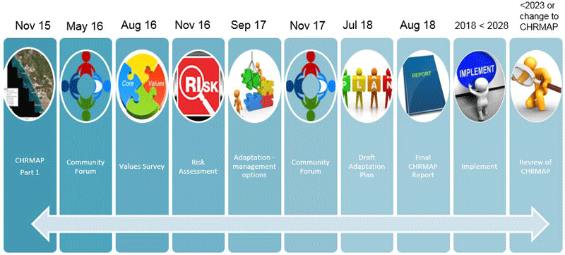
To assist in understanding of the Coastal Hazard Risk Management & Adaptation Plan (CHRMAP) process, a series of information posters is provided below.
What’s Next
The City has now begun the Implementation phase of the CHRMAP.
The City’s CHRMAP will be updated and reviewed every five to ten years, and in accordance with the State Planning Policy 2.6 and associated guidelines.
Should you have any further queries, please contact our Environmental team on 9405 5372.